 Storm of the Century...
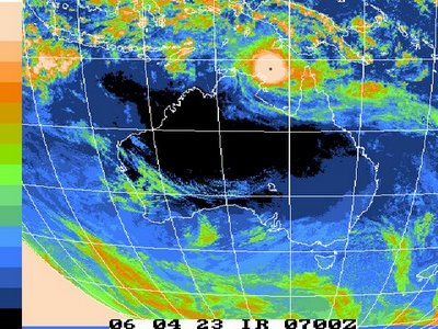
This is a picture of a map of Australia from the Bureau of Meterology, Darwin, Northern Territory, Australia. On it, as you can see, is Cyclone Monica, more severe than Cyclone Tracy, which destroyed Darwin Christmas Eve night, 1974.
No one, back in those days, could accurately distinguish what the actual wind speed was as technology was not what it is today, and can only guesstimate what the destructive wind speed was. We do know that Tracy moved at only 8 kilometres per hour when she crossed the coast at Darwin. She stayed with us the entire night of 24 December. Many people died that night as the weather bureau, following the path of Tracy, was located in our national capital, Canberra, over 1500 miles to the south.
36 years later and here comes Monica, a catagory 5 cyclone with winds at the destructive centre measured near 350 kilometres per hour. That is over 200 miles per hour on the old scale. Try standing up in those conditions. This storm surpasses Katrina and is indeed the storm of the century, but then again, this is no pissing contest.
To make matters worse are the high tides experienced in this part of the world, up to nine metres, or 27 feet on the old scale. Big tides indeed! Storm surges, if Monica hits at high tide, will wipe out a large portion of the population if it hits Darwin. We were lucky in 1974; Tracy struck at low tide. Let's hope luck is still on our side.
As I am not a weatherman so I will leave you with this Cyclone warning issued by the Bureau of Meterology:
Darwin Regional Forecasting CentreTOP PRIORITYMEDIA:
Transmitters serving the Gove area are requested to use the cyclone mergency warning signal with this message.
TROPICAL CYCLONE WARNINGTROPICAL CYCLONE ADVICE NUMBER 56 Issued by the BUREAU OF METEOROLOGY, DARWINat 5:00 pm CST Sunday 23 April 2006
A CYCLONE WARNING is now current for coastal and island communities between CAPESHIELD and POINT STUART, including NHULUNBUY, JABIRU AND COBOURG PENINSULA.
CYCLONE WATCH extends southwest between POINT STUART and PORT KEATS, including DARWIN and the TIWI ISLANDS.
At 4 pm CST SEVERE TROPICAL CYCLONE Monica CATEGORY 5 was located about 110 kilometres northeast of NHULUNBUY, and 210 kilometres east northeast of ELCHO ISLAND, moving west at 12 kilometres per hour.
The cyclone should remain close to its current intensity as it moves further west, just north of the north coast overnight. The VERY DESTRUCTIVE core of SEVERE TROPICAL CYCLONE Monica with gusts to 350 kilometres per hour is expected to impact islands of northeast Arnhem Land, including ELCHO ISLAND tonight. The VERY DESTRUCTIVE core is expected to impact the north coast of western ARNHEM LAND between MILINGIMBI and CROKER ISLAND during Monday. The cyclone is expected to weaken slightly as it passes over the base of the COBOURG PENINSULA before reaching the northwest DARWIN-DALY and TIWI ISLAND area on Tuesday.
GALES with gusts to 100 kilometres per hour are currently being experienced on the far northeast Arnhem Land coast and Wessel Islands. DESTRUCTIVE WINDS with gusts to 160 kilometres per hour are expected to develop along the Arnhem Land coast between NHULUNBUY and ELCHO ISLAND tonight and extend further west to MANINGRIDA and GOULBURN ISLAND during Monday. GALES near the outer edge of the cyclone may extend as far as POINT STUART and COBOURG PENINSULA on Monday night. GALES will continue to extend westward and may develop over the northwest DARWIN-DALY and TIWI ISLAND area during Monday night and Tuesday morning.
DANGEROUSLY HIGH TIDES could cause EXTENSIVE FLOODING at the coast between CAPESHIELD and ELCHO ISLAND during today. HEAVY RAIN is expected to cause significant stream rises and flooding of lowlying areas in northeastern Arnhem land today, extending across the remainder ofthe northern Top End on Monday.
Details of SEVERE TROPICAL CYCLONE Monica at 4 pm CST:
Centre located near...... 11.4 degrees South 137.4 degrees East .
Location accuracy........ within 30 kilometres . +
Recent movement.......... towards the west at 12 km/h . Wind gusts near centre... 350 kilometres per hour .
Intensity................ CATEGORY 5 .
Central pressure......... 905 hectoPascals
REPEATING: A CYCLONE WARNING is now current between CAPE SHIELD and POINT STUART, including NHULUNBUY, JABIRU and COBOURG PENINSULA. A CYCLONE WATCH extends southwest to PORT KEATS, including DARWIN and the TIWI ISLANDS.
The next advice will be issued at 8 pm CST.This advice is available on telephone NT-1300 659 211
DARWIN Tropical Cyclone Warning Centre


0 Comments:
Post a Comment
<< Home